


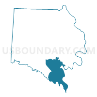
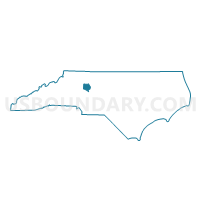
Voting District 07, Davie County, North Carolina
About
Outline

Summary
| Unique Area Identifier | 639900 |
| Name | Voting District 07 |
| County | Davie County |
| State | North Carolina |
| Area (square miles) | 22.83 |
| Land Area (square miles) | 22.41 |
| Water Area (square miles) | 0.42 |
| % of Land Area | 98.15 |
| % of Water Area | 1.85 |
| Latitude of the Internal Point | 35.81480890 |
| Longtitude of the Internal Point | -80.50116640 |
Maps

Graphs
Select a template below for downloading or customizing gragh for Voting District 07, Davie County, North Carolina


Neighbors
Neighoring Voting District (by Name) Neighboring Voting District on the Map
- Voting District 04, Davie County, NC
- Voting District 06, Davie County, NC
- Voting District 06, Davidson County, NC
- Voting District 09, Davie County, NC
- Voting District 11, Rowan County, NC
- Voting District 32, Rowan County, NC
- Voting District 78, Davidson County, NC
Top 10 Neighboring County Subdivision (by Population) Neighboring County Subdivision on the Map
- Franklin township, Rowan County, NC (12,322)
- Mocksville township, Davie County, NC (9,837)
- Tyro township, Davidson County, NC (9,025)
- Jerusalem township, Davie County, NC (6,062)
- Boone township, Davidson County, NC (4,753)
- Fulton township, Davie County, NC (2,281)
- Unity township, Rowan County, NC (2,215)
Top 10 Neighboring Unified School District (by Population) Neighboring Unified School District on the Map
- Rowan-Salisbury Schools, NC (130,380)
- Davidson County Schools, NC (127,662)
- Davie County Schools, NC (41,240)
Top 10 Neighboring State Legislative District Lower Chamber (by Population) Neighboring State Legislative District Lower Chamber on the Map
- State House District 79, NC (74,556)
- State House District 77, NC (67,312)
- State House District 81, NC (65,650)
Top 10 Neighboring State Legislative District Upper Chamber (by Population) Neighboring State Legislative District Upper Chamber on the Map
Top 10 Neighboring 111th Congressional District (by Population) Neighboring 111th Congressional District on the Map
Top 10 Neighboring Census Tract (by Population) Neighboring Census Tract on the Map
- Census Tract 617.02, Davidson County, NC (6,730)
- Census Tract 519.02, Rowan County, NC (6,395)
- Census Tract 807, Davie County, NC (6,393)
- Census Tract 804, Davie County, NC (5,151)
- Census Tract 513.02, Rowan County, NC (4,540)
- Census Tract 805, Davie County, NC (4,428)
Top 10 Neighboring 5-Digit ZIP Code Tabulation Area (by Population) Neighboring 5-Digit ZIP Code Tabulation Area on the Map
- 27295, NC (37,211)
- 27028, NC (25,839)
- 28144, NC (24,734)
- 28147, NC (24,697)
- 27006, NC (14,150)
- 27299, NC (5,190)
- 27054, NC (2,567)